
Washtenaw County topographic map
Interactive map
Click on the map to display elevation.
About this map
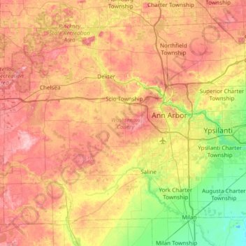
Name: Washtenaw County topographic map, elevation, terrain.
Location: Washtenaw County, Michigan, United States of America (42.07158 -84.13408 42.43518 -83.53940)
Average elevation: 267 m
Minimum elevation: 194 m
Maximum elevation: 344 m
Other topographic maps
Click on a map to view its topography, its elevation and its terrain.
Ann Arbor
United States of America > Michigan > Ann Arbor
Ann Arbor, Washtenaw County, Michigan, United States of America
Average elevation: 268 m
Sanilac County
United States of America > Michigan
Sanilac County, Michigan, United States of America
Average elevation: 228 m