
Brixton topographic map
Interactive map
Click on the map to display elevation.
About this map
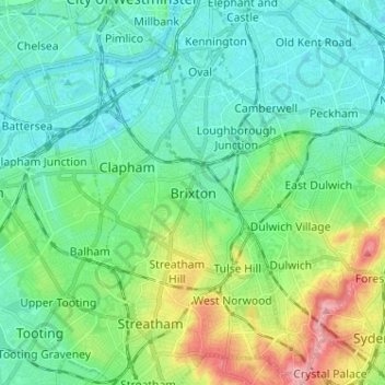
Name: Brixton topographic map, elevation, terrain.
Location: Brixton, Greater London, England, SW2 1SS, United Kingdom (51.41680 -0.15680 51.49680 -0.07680)
Average elevation: 29 m
Minimum elevation: -2 m
Maximum elevation: 114 m
Other topographic maps
Click on a map to view its topography, its elevation and its terrain.
Bath
United Kingdom > England > Bath and North East Somerset
Bath is in the Avon Valley and is surrounded by limestone hills as it is near the southern edge of the Cotswolds, a designated Area of Outstanding Natural Beauty, and the limestone Mendip Hills rise around 7 miles (11 km) south of the city. The hills that surround and make up the city have a maximum altitude…
Average elevation: 100 m
South East England
Near Weybridge are the UK headquarters of Sony with SSP Group (situated in Byfleet) and Procter & Gamble (next door to each other on The Heights Business Park near the former Brooklands racing circuit) with Kia Motors UK and Petroleum Geo-Services UK, and Gallaher Group (cigarettes) is to the north, next to…
Average elevation: 69 m
London
London's topography is characterized by a gently rolling terrain shaped by the River Thames and its tributaries. The city lies within the London Basin, a natural depression bordered by higher grounds such as the North Downs to the south and the Chiltern Hills to the northwest. The Thames flows west to east,…
Average elevation: 66 m
Kent
Kent was also the location of the largest number of art schools in the country during the nineteenth century, estimated by the art historian David Haste, to approach two hundred. This is believed to be the result of Kent being a front line county during the Napoleonic Wars. At this time, before the invention…
Average elevation: 37 m
Suffolk
The west of the county lies on more resistant Cretaceous chalk. This chalk is responsible for a sweeping tract of largely downland landscapes that stretches from Dorset in the south west to Dover in the south east and north through East Anglia to the Yorkshire Wolds. The chalk is less easily eroded so forms…
Average elevation: 35 m
Cambridge
United Kingdom > England > Cambridge
The city, like most of the UK, has a maritime climate highly influenced by the Gulf Stream. Located in the driest region of Britain, Cambridge's rainfall averages around 570 mm (22.44 in) per year, around half the national average, with some years occasionally falling into the semi-arid (under 500 mm (19.69…
Average elevation: 18 m
Cornwall
The interior of the county consists of a roughly east–west spine of infertile and exposed upland, with a series of granite intrusions, such as Bodmin Moor, which contains the highest land within Cornwall. From east to west, and with approximately descending altitude, these are Bodmin Moor, Hensbarrow north…
Average elevation: 55 m
Exeter
United Kingdom > England > Devon
The city of Exeter was established on the eastern bank of the River Exe on a ridge of land backed by a steep hill. It is at this point that the Exe, having just been joined by the River Creedy, opens onto a wide flood plain and estuary which results in quite common flooding. Historically this was the lowest…
Average elevation: 56 m
Birmingham
Birmingham is a snowy city relative to other large UK conurbations, due to its inland location and comparatively high elevation. Between 1961 and 1990 Birmingham Airport averaged 13.0 days of snow lying annually, compared to 5.33 at London Heathrow. Snow showers often pass through the city via the Cheshire gap…
Average elevation: 138 m
Hertfordshire
Elevations are higher in the north and west, reaching more than 800 feet (240 m) in the Chilterns near Tring. The county centres on the headwaters and upper valleys of the rivers Lea and the Colne; both flow south, and each is accompanied by a canal. Hertfordshire's undeveloped land is mainly agricultural,…
Average elevation: 82 m
Somerset
Many settlements developed because of their strategic importance in relation to geographical features, such as river crossings or valleys in ranges of hills. Examples include Axbridge on the River Axe, Castle Cary on the River Cary, North Petherton on the River Parrett, and Ilminster, where there was a…
Average elevation: 96 m
Worthington
United Kingdom > England > Leicestershire > North West Leicestershire
Average elevation: 103 m
Scredington
United Kingdom > England > Lincolnshire > North Kesteven > Scredington
Average elevation: 13 m
Plymouth
The River Plym, which flows off Dartmoor to the north-east, forms a smaller estuary to the east of the city called Cattewater. Plymouth Sound is protected from the sea by the Plymouth Breakwater, in use since 1814. In the Sound is Drake's Island which is seen from Plymouth Hoe, a flat public area on top of…
Average elevation: 46 m
East of England
The East of England region has the lowest elevation range in the UK. Twenty percent of the region is below mean sea level, most of this in North Cambridgeshire, Norfolk and on the Essex Coast. Most of the remaining area is of low elevation, with extensive glacial deposits. The Fens, a large area of reclaimed…
Average elevation: 39 m
Cambridge
United Kingdom > England > Cambridgeshire
The city, like most of the UK, has a maritime climate highly influenced by the Gulf Stream. Located in the driest region of Britain, Cambridge's rainfall averages around 570 mm (22.44 in) per year, around half the national average, The driest recent year was in 2011 with 380.4 mm (14.98 in) of rain at the…
Average elevation: 18 m
Balderton
United Kingdom > England > Nottinghamshire > Newark and Sherwood > Balderton
Average elevation: 20 m
Lake District National Park
The Lake District is a roughly circular upland massif, deeply dissected by a broadly radial pattern of major valleys which are largely the result of repeated glaciations over the last 2 million years. The apparent radial pattern is not from a central dome, but from an axial watershed extending from St Bees…
Average elevation: 206 m
Dartmoor National Park
United Kingdom > England > Devon
Rainfall tends to be associated with Atlantic depressions or with convection. In summer, convection caused by solar surface heating sometimes forms shower clouds and a large proportion of rainfall falls from showers and thunderstorms at this time of year. The wettest months are November and December and on the…
Average elevation: 239 m
Cambridgeshire
Cambridgeshire has a maritime temperate climate which is broadly similar to the rest of the United Kingdom, though it is drier than the UK average due to its low altitude and easterly location, the prevailing southwesterly winds having already deposited moisture on higher ground further west. Average winter…
Average elevation: 32 m
Lincoln
United Kingdom > England > Lincolnshire
Lincoln lies 157 mi (253 km) north of London, at an altitude of 67 ft (20.4 m) by the River Witham up to 246 ft (75.0 m) on Castle Hill. It fills a gap in the Lincoln Cliff escarpment, which runs north and south through central Lincolnshire, with altitudes up to 200 feet (61 metres). The city lies on the River…
Average elevation: 29 m
Ipswich
United Kingdom > England > Suffolk
Ipswich experiences an oceanic climate, like the rest of the British Isles, with a narrow range of temperature and rainfall spread evenly throughout the year. One of the two nearest for which data is available is East Bergholt, about 7 miles (11 km) south west of the town centre and at a similar elevation, and…
Average elevation: 29 m
Former Seaton Ironworks Reservoir (disused)
United Kingdom > England > Cumberland > Workington > Stainburn
Average elevation: 32 m
Buxton
United Kingdom > England > Derbyshire > High Peak
Buxton has an oceanic climate with short, mild summers and long, cool winters. At about 1,000 feet (300 m) above sea level, As the highest market town in England, Buxton's elevation makes it cooler and wetter than surrounding towns, with a daytime temperature typically about 2 °C lower than Manchester.
Average elevation: 334 m
East Midlands
The highest point at 636 m (2,087 ft) is Kinder Scout, in the Peak District of the southern Pennines in northwest Derbyshire near Glossop. Other hilly areas of 95 to 280 m (312 to 919 ft) in altitude, together with lakes and reservoirs, rise in and around the Charnwood Forest north of Peterborough, Leicester,…
Average elevation: 75 m
Yorkshire
In Yorkshire there is a very close relationship between the major topographical areas and the geological period in which they were formed. The Pennine chain of hills in the west is of Carboniferous origin. The central vale is Permo-Triassic. The North York Moors in the north-east of the county are Jurassic in…
Average elevation: 130 m
Staunton Harold Reservoir
United Kingdom > England > Derbyshire > South Derbyshire > Melbourne CP
Average elevation: 93 m
Blea Tarn
United Kingdom > England > Cumberland > Boot > Beckfoot
Blea Tarn is a lake in Eskdale, Cumbria, in the English Lake District, located about half a mile north of Beckfoot. Located at an elevation of 217 m (712 ft), the lake has an area of 3.3 hectares (8.2 acres) and measures 277 m × 150 m (909 ft × 492 ft), with a maximum depth of 11 m (36 ft).
Average elevation: 144 m
Haslemere
United Kingdom > England > Surrey > Waverley
Many of the roads in the area originated as medieval tracks and owing to the local topography, are narrow, twisting and steep. The principal route through Haslemere is the A286, which connects the town with Godalming and Grayswood (to the north) and with Midhurst (to the south). The A287 runs south from…
Average elevation: 150 m
Portsmouth
Portsmouth is 73.5 miles (118.3 km) by road from central London, 49.5 miles (79.7 km) west of Brighton, and 22.3 miles (35.9 km) east of Southampton. It is located primarily on Portsea Island and is the United Kingdom's only island city, although the city has expanded to the mainland. Gosport is a borough to…
Average elevation: 7 m