
Güvercintepe Mahallesi topographic map
Interactive map
Click on the map to display elevation.
About this map
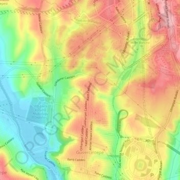
Name: Güvercintepe Mahallesi topographic map, elevation, terrain.
Average elevation: 79 m
Minimum elevation: -1 m
Maximum elevation: 147 m
Other topographic maps
Click on a map to view its topography, its elevation and its terrain.
Başak Mahallesi
Başak Mahallesi, Başakşehir, Istanbul, Marmara Region, 34480, Turkey
Average elevation: 134 m