
Dublin topographic map
Interactive map
Click on the map to display elevation.
About this map
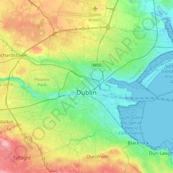
Name: Dublin topographic map, elevation, terrain.
Location: Dublin, County Dublin, Leinster, Ireland (53.29873 -6.38703 53.41054 -6.11488)
Average elevation: 42 m
Minimum elevation: -2 m
Maximum elevation: 131 m
Other topographic maps
Click on a map to view its topography, its elevation and its terrain.
Malahide
Ireland > County Dublin > Malahide
Malahide, Fingal, County Dublin, Leinster, K36 HN84, Ireland
Average elevation: 10 m
Rowlestown
Ireland > County Dublin > Rowlestown
Rowlestown, Fingal, County Dublin, Leinster, Ireland
Average elevation: 49 m