
Stoneham-et-Tewkesbury topographic map
Interactive map
Click on the map to display elevation.
About this map
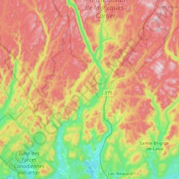
Name: Stoneham-et-Tewkesbury topographic map, elevation, terrain.
Average elevation: 528 m
Minimum elevation: 148 m
Maximum elevation: 1,011 m
Other topographic maps
Click on a map to view its topography, its elevation and its terrain.
Valcartier
Canada > Quebec > La Jacques-Cartier > Saint-Gabriel-de-Valcartier
Average elevation: 170 m
Lac Saint-Thomas
Canada > Quebec > La Jacques-Cartier > Stoneham-et-Tewkesbury
Average elevation: 505 m