
Penang topographic map
Interactive map
Click on the map to display elevation.
About this map
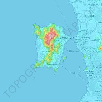
Name: Penang topographic map, elevation, terrain.
Location: Penang, Malaysia (5.12200 100.17498 5.58568 100.55031)
Average elevation: 18 m
Minimum elevation: -3 m
Maximum elevation: 798 m
Penang Island is irregularly shaped, with a hilly and mostly forested interior; its coastal plains are narrow, the most extensive of which is at the northeastern cape. With a height of 833 m (2,733 ft), Penang Hill, at the centre of the island, is the tallest point within Penang. From a small settlement at the northeastern tip of Penang Island, George Town has expanded over the centuries, particularly in the northwestern, western and southern directions, eventually linking up with Bayan Lepas at the island's southeast and urbanising the entire eastern coast of the island. Meanwhile, the topography of Seberang Perai is mostly flat, save for a few hills such as Bukit Mertajam.
Other topographic maps
Click on a map to view its topography, its elevation and its terrain.
George Town
Malaysia > Penang > George Town
George Town, Timur Laut, Penang, 10000, Malaysia
Average elevation: 38 m
Butterworth
Malaysia > Penang > Butterworth
Butterworth, Seberang Perai Utara, Province Wellesley, Penang, 12000, Malaysia
Average elevation: 39 m
Bayan Lepas
Malaysia > Penang > Bayan Lepas
Bayan Lepas, Barat Daya, Penang, 11900, Malaysia
Average elevation: 28 m
Air Itam Dam
Malaysia > Penang > Titi Teras
Air Itam Dam, Jl. Balik Pulau, Titi Teras, Barat Daya, Penang, 11500, Malaysia
Average elevation: 317 m