
Thank you for supporting this site ❤️
Make a donation
Make a donation
Karabük topographic map
Click on the map to display elevation.
Thank you for supporting this site ❤️
Make a donation
Make a donation
Karabük
Karabük is a town and the capital district of Karabük Province in the Black Sea region of Turkey. According to the 2009 census, population of the city is 108 167. The district covers an area of 760 km2 (293 sq mi), and the town lies at an elevation of 354 m (1,161 ft).
Thank you for supporting this site ❤️
Make a donation
Make a donation
About this map
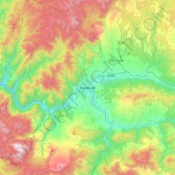
Name: Karabük topographic map, elevation, terrain.
Average elevation: 864 m
Minimum elevation: 161 m
Maximum elevation: 1,997 m
Thank you for supporting this site ❤️
Make a donation
Make a donation