
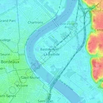
La Bastide topographic map
Interactive map
Click on the map to display elevation.
About this map
Name: La Bastide topographic map, elevation, terrain.
Average elevation: 12 m
Minimum elevation: -4 m
Maximum elevation: 75 m
Other topographic maps
Click on a map to view its topography, its elevation and its terrain.
Chartrons - Grand Parc - Jardin Public
France > Nouvelle-Aquitaine > Bordeaux
Chartrons - Grand Parc - Jardin Public, Bordeaux, Gironde, Nouvelle-Aquitaine, France métropolitaine, 33000, France
Average elevation: 9 m
Nansouty - Saint-Genès
France > Nouvelle-Aquitaine > Bordeaux
Nansouty - Saint-Genès, Bordeaux, Gironde, Nouvelle-Aquitaine, France métropolitaine, 33000, France
Average elevation: 16 m
Bassins à flot
France > Nouvelle-Aquitaine > Bordeaux
Bassins à flot, Place Lewis Brown, Bordeaux Maritime, Bordeaux, Nouvelle-Aquitaine, France métropolitaine, 33300, France
Average elevation: 5 m
Saint-Augustin - Tauzin - Alphonse Dupeux
France > Nouvelle-Aquitaine > Bordeaux
Saint-Augustin - Tauzin - Alphonse Dupeux, Bordeaux, Gironde, Nouvelle-Aquitaine, France métropolitaine, 33000, France
Average elevation: 19 m
Centre ville
France > Nouvelle-Aquitaine > Bordeaux
Centre ville, Bordeaux, Gironde, Nouvelle-Aquitaine, France métropolitaine, 33000, France
Average elevation: 14 m