
Menderes topographic map
Interactive map
Click on the map to display elevation.
About this map
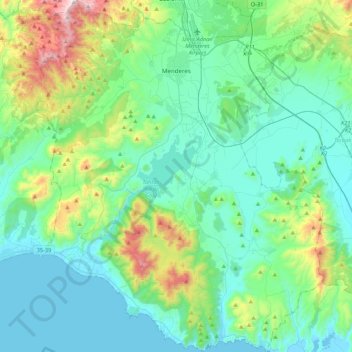
Name: Menderes topographic map, elevation, terrain.
Location: Menderes, Izmir, Aegean Region, Turkey (37.98007 26.94379 38.31909 27.31370)
Average elevation: 198 m
Minimum elevation: -2 m
Maximum elevation: 1,005 m
Other topographic maps
Click on a map to view its topography, its elevation and its terrain.
Mithatpaşa Mahallesi
Mithatpaşa Mahallesi, Menderes, Izmir, Aegean Region, Turkey
Average elevation: 110 m
Oğlananası
Turkey > Menderes > Oğlananası
Oğlananası, Menderes, Izmir, Aegean Region, 35470, Turkey
Average elevation: 137 m