
Tracadie topographic map
Interactive map
Click on the map to display elevation.
About this map
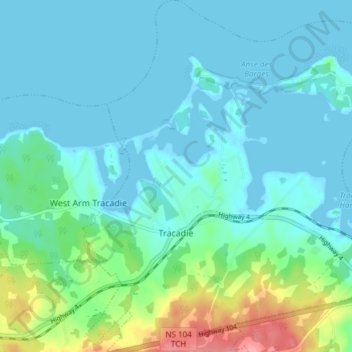
Name: Tracadie topographic map, elevation, terrain.
Average elevation: 17 m
Minimum elevation: -1 m
Maximum elevation: 92 m
Other topographic maps
Click on a map to view its topography, its elevation and its terrain.
Loch Katrine
Canada > Nouvelle-Écosse > Municipality of the County of Antigonish
Loch Katrine, Municipality of the County of Antigonish, Antigonish County, Nouvelle-Écosse, Canada
Average elevation: 126 m
Georgeville
Canada > Nouvelle-Écosse > Municipality of the County of Antigonish
Georgeville, Municipality of the County of Antigonish, Antigonish County, Nouvelle-Écosse, Canada
Average elevation: 66 m