
Jaroslawl topographic map
Interactive map
Click on the map to display elevation.
About this map
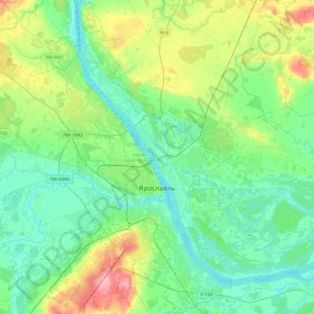
Name: Jaroslawl topographic map, elevation, terrain.
Average elevation: 108 m
Minimum elevation: 80 m
Maximum elevation: 189 m
Jaroslawl und die Oblast Jaroslawl befinden sich im zentralen Teil der Osteuropäischen Ebene, die in Gebieten nordöstlich von Moskau durch eine Hügellandschaft mit Höhen von meist nicht mehr als 200 Meter geprägt ist. Typisch für die natürliche Landschaft der Oblast Jaroslawl ist der Reichtum an Misch- und Nadelwäldern, stellenweise gibt es auch größere Sumpfflächen.
Other topographic maps
Click on a map to view its topography, its elevation and its terrain.
Rostow
Russland > Oblast Jaroslawl > Rostow
Rostow, Ростовский район, Oblast Jaroslawl, Föderationskreis Zentralrussland, Russland
Average elevation: 99 m
Rybinsker Stausee
Rybinsker Stausee, Пошехонский район, Oblast Jaroslawl, Föderationskreis Zentralrussland, Russland
Average elevation: 127 m