
Bashkortostan topographic map
Interactive map
Click on the map to display elevation.
About this map
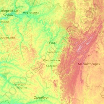
Name: Bashkortostan topographic map, elevation, terrain.
Location: Bashkortostan, Volga Federal District, Russia (51.56955 53.15754 56.53461 60.00181)
Average elevation: 289 m
Minimum elevation: 50 m
Maximum elevation: 1,602 m
Other topographic maps
Click on a map to view its topography, its elevation and its terrain.
Тагил
Russia > Sverdlovsk Oblast > городской округ Нижний Тагил > Nizhny Tagil
Average elevation: 203 m
Siberia
Eastern and central Sakha comprises numerous north–south mountain ranges of various ages. These mountains extend up to almost 3,000 metres (9,800 ft), but above a few hundred metres they are almost completely devoid of vegetation. The Verkhoyansk Range was extensively glaciated in the Pleistocene, but the…
Average elevation: 333 m