
Riverdale topographic map
Interactive map
Click on the map to display elevation.
About this map
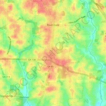
Name: Riverdale topographic map, elevation, terrain.
Location: Riverdale, Clayton County, Georgia, United States (33.52101 -84.43425 33.58840 -84.39033)
Average elevation: 272 m
Minimum elevation: 240 m
Maximum elevation: 303 m
Other topographic maps
Click on a map to view its topography, its elevation and its terrain.
Camp Orr Dam
United States > Georgia > Clayton County
Camp Orr Dam, Clayton County, Georgia, 30250, United States
Average elevation: 266 m
Lovejoy
United States > Georgia > Clayton County
Lovejoy, Clayton County, Georgia, United States
Average elevation: 275 m
Forest Park
United States > Georgia > Clayton County
Forest Park, Clayton County, Georgia, 30297, United States
Average elevation: 283 m