
Ümraniye topographic map
Interactive map
Click on the map to display elevation.
Ümraniye
Due to its elevated altitude, the full scene of Istanbul, including Bosphorus and European Side, can be seen from Ümraniye.
About this map
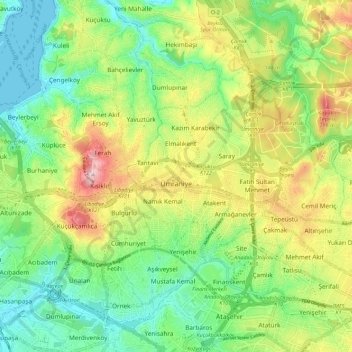
Name: Ümraniye topographic map, elevation, terrain.
Location: Ümraniye, Istanbul, Marmara Region, Turkey (40.98897 29.08035 41.06545 29.19466)
Average elevation: 99 m
Minimum elevation: 0 m
Maximum elevation: 263 m
Other topographic maps
Click on a map to view its topography, its elevation and its terrain.
Istanbul
Istanbul, located in northwestern Turkey, is a city that is uniquely situated across two continents, Europe and Asia, divided by the Bosphorus Strait. The city’s topography is characterized by a complex blend of hills, valleys, and coastal plains, which create a varied and scenic landscape. The European side…
Average elevation: 57 m