
东营市 topographic map
Interactive map
Click on the map to display elevation.
About this map
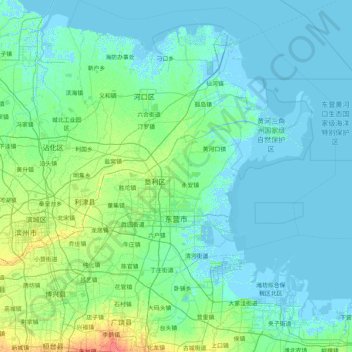
Name: 东营市 topographic map, elevation, terrain.
Location: 东营市, 山东省, 257000, 中国 (36.93599 118.10652 38.24000 119.41452)
Average elevation: 4 m
Minimum elevation: -5 m
Maximum elevation: 34 m
Other topographic maps
Click on a map to view its topography, its elevation and its terrain.
昌邑市城市规划技术服务中心潍河西开放式养殖项目
昌邑市城市规划技术服务中心潍河西开放式养殖项目, 昌邑市, 潍坊市, 山东省, 中国
Average elevation: 0 m