
淄博市 topographic map
Interactive map
Click on the map to display elevation.
About this map
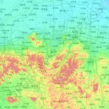
Name: 淄博市 topographic map, elevation, terrain.
Location: 淄博市, 山东省, 中国 (35.92446 117.54482 37.28193 118.51704)
Average elevation: 190 m
Minimum elevation: -1 m
Maximum elevation: 1,045 m
Other topographic maps
Click on a map to view its topography, its elevation and its terrain.
昌邑市城市规划技术服务中心潍河西开放式养殖项目
昌邑市城市规划技术服务中心潍河西开放式养殖项目, 昌邑市, 潍坊市, 山东省, 中国
Average elevation: 0 m