
Guipry-Messac topographic map
Interactive map
Click on the map to display elevation.
About this map
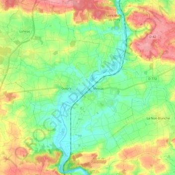
Name: Guipry-Messac topographic map, elevation, terrain.
Average elevation: 49 m
Minimum elevation: 3 m
Maximum elevation: 125 m
Other topographic maps
Click on a map to view its topography, its elevation and its terrain.
L'Abbaye de Saint-Sulpice
France > Brittany > Ille-et-Vilaine > Saint-Sulpice-la-Forêt
Average elevation: 68 m
Fort du Guesclin
France > Brittany > Ille-et-Vilaine > Saint-Coulomb > La Basse Ville Énoux
Average elevation: 10 m
Saint-Charles
France > Brittany > Ille-et-Vilaine > Sixt-sur-Aff > Saint-Charles
Average elevation: 49 m