
Odunpazarı topographic map
Interactive map
Click on the map to display elevation.
About this map
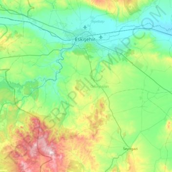
Name: Odunpazarı topographic map, elevation, terrain.
Location: Odunpazarı, Eskişehir, Central Anatolia Region, Turkey (39.44150 30.21141 39.82280 30.88524)
Average elevation: 1,011 m
Minimum elevation: 767 m
Maximum elevation: 1,815 m
Other topographic maps
Click on a map to view its topography, its elevation and its terrain.
Sümer Mahallesi
Sümer Mahallesi, Odunpazarı, Eskişehir, Central Anatolia Region, Turkey
Average elevation: 802 m