
South Kingstown topographic map
Interactive map
Click on the map to display elevation.
About this map
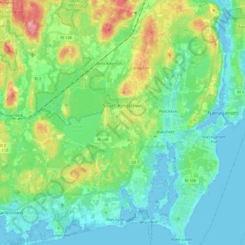
Name: South Kingstown topographic map, elevation, terrain.
Average elevation: 30 m
Minimum elevation: -5 m
Maximum elevation: 114 m
Other topographic maps
Click on a map to view its topography, its elevation and its terrain.
Mooresfield
United States of America > Rhode Island > South Kingstown > Mooresfield
Mooresfield, South Kingstown, Washington County, Rhode Island, 02881, United States of America
Average elevation: 40 m