
Ngong Ping topographic map
Interactive map
Click on the map to display elevation.
About this map
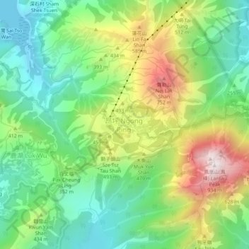
Name: Ngong Ping topographic map, elevation, terrain.
Location: Ngong Ping, Islands District, Hong Kong, PRC (22.23578 113.88434 22.27578 113.92434)
Average elevation: 324 m
Minimum elevation: -2 m
Maximum elevation: 885 m
Other topographic maps
Click on a map to view its topography, its elevation and its terrain.
Lantau North Country Park
Lantau North Country Park, Ngong Ping 360 Rescue Trail, Sha Lo Wan, Ngong Ping, Islands District, Hong Kong, 000000, PRC
Average elevation: 232 m