
Thank you for supporting this site ❤️
Make a donation
Make a donation
Berkeley topographic map
Click on the map to display elevation.
Thank you for supporting this site ❤️
Make a donation
Make a donation
Berkeley
In 1866, Oakland's private College of California looked for a new site. It settled on a location north of Oakland along the foot of the Contra Costa Range (later called the Berkeley Hills) on Strawberry Creek, at an elevation of about 500 feet (150 m) above the bay, commanding a view of the Bay Area and the Pacific Ocean through the Golden Gate.
Thank you for supporting this site ❤️
Make a donation
Make a donation
About this map
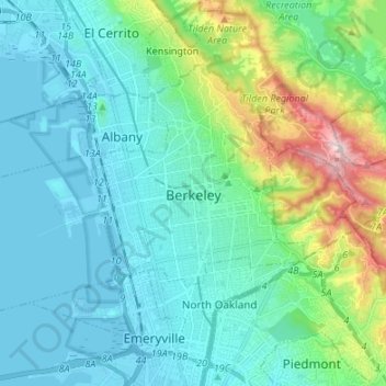
Name: Berkeley topographic map, elevation, terrain.
Location: Berkeley, Alameda County, California, United States (37.83573 -122.36868 37.90669 -122.23420)
Average elevation: 109 m
Minimum elevation: -5 m
Maximum elevation: 570 m
Thank you for supporting this site ❤️
Make a donation
Make a donation