
Krishna topographic map
Interactive map
Click on the map to display elevation.
About this map
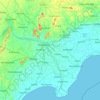
Name: Krishna topographic map, elevation, terrain.
Location: Krishna, Andhra Pradesh, India (15.71226 80.00844 17.15318 81.57061)
Average elevation: 42 m
Minimum elevation: -2 m
Maximum elevation: 526 m
Other topographic maps
Click on a map to view its topography, its elevation and its terrain.
Bhimavaram
India > Andhra Pradesh > Bhimavaram
Bhimavaram, West Godavari, Andhra Pradesh, 534200, India
Average elevation: 6 m
Eluru
India > Andhra Pradesh > Eluru
Eluru, West Godavari, Andhra Pradesh, 534001, India
Average elevation: 22 m
Sathyavanipalem
India > Andhra Pradesh > Sathyavanipalem
Sathyavanipalem, Visakhapatnam, Andhra Pradesh, 530046, India
Average elevation: 25 m