
Linn County topographic map
Interactive map
Click on the map to display elevation.
About this map
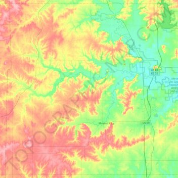
Name: Linn County topographic map, elevation, terrain.
Location: Linn County, Kansas, United States (38.03645 -95.07892 38.38963 -94.61249)
Average elevation: 283 m
Minimum elevation: 235 m
Maximum elevation: 343 m
Other topographic maps
Click on a map to view its topography, its elevation and its terrain.
St. John
United States > Kansas > Stafford County
St. John, Stafford County, Kansas, 67576, United States
Average elevation: 581 m
Wichita County
United States > Kansas > Wichita County
Wichita County, Kansas, United States
Average elevation: 1,004 m