
Knoxville topographic map
Interactive map
Click on the map to display elevation.
About this map
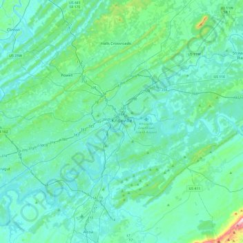
Name: Knoxville topographic map, elevation, terrain.
Average elevation: 307 m
Minimum elevation: 232 m
Maximum elevation: 881 m
According to the United States Census Bureau, the city has a total area of 104.2 square miles (269.8 km2), of which 98.5 square miles (255.2 km2) is land and 5.6 square miles (14.6 km2), or 5.42%, is water. Elevations range from just over 800 feet (240 m) along the riverfront to just over 1,000 feet (300 m) on various hilltops in West Knoxville, with the downtown area resting at just over 900 feet (270 m). High points include Sharp's Ridge in North Knoxville at 1,391 feet (424 m) and Brown Mountain in South Knoxville at 1,260 feet (380 m). House Mountain, the highest point in Knox County at 2,064 feet (629 m), is located east of the city near Mascot.
Other topographic maps
Click on a map to view its topography, its elevation and its terrain.
University of Tennessee
United States > Tennessee > Knox County > Knoxville
University of Tennessee, Knoxville, Knox County, East Tennessee, Tennessee, United States
Average elevation: 272 m
Knoxville
United States > Tennessee > Knox County > Knoxville
Knoxville, Knox County, Tennessee, 37996-4134, United States
Average elevation: 304 m
Buffat Heights
United States > Tennessee > Knox County > Knoxville
Buffat Heights, Knoxville, Knox County, East Tennessee, Tennessee, 37914, United States
Average elevation: 303 m
Farragut
United States > Tennessee > Knox County
Farragut, Knox County, East Tennessee, Tennessee, 37934, United States
Average elevation: 281 m
Seven Islands State Birding Park
United States > Tennessee > Knox County
Seven Islands State Birding Park, Kelly Lane, Seven Islands, Knox County, East Tennessee, Tennessee, 37764, United States
Average elevation: 280 m
Shooks
United States > Tennessee > Knox County
Shooks, Knox County, East Tennessee, Tennessee, United States
Average elevation: 293 m
Ijams Nature Center
United States > Tennessee > Knox County > Knoxville
Ijams Nature Center, Alamo Avenue Southeast, Knoxville, Knox County, East Tennessee, Tennessee, 37920, United States
Average elevation: 268 m
Graveston
United States > Tennessee > Knox County
Graveston, Knox County, East Tennessee, Tennessee, 37721, United States
Average elevation: 354 m
Heather Heights
United States > Tennessee > Knox County
Heather Heights, Knox County, East Tennessee, Tennessee, 37931, United States
Average elevation: 318 m
Karns
United States > Tennessee > Knox County
Karns, Knox County, East Tennessee, Tennessee, 37931, United States
Average elevation: 314 m
Vestal
United States > Tennessee > Knox County > Knoxville
Vestal, Knoxville, Knox County, Tennessee, 37920, United States
Average elevation: 284 m
Powell
United States > Tennessee > Knox County
Powell, Knox County, East Tennessee, Tennessee, 37849, United States
Average elevation: 329 m
House Mountain
United States > Tennessee > Knox County
House Mountain, Knox County, Tennessee, 37806, United States
Average elevation: 396 m
Farrington
United States > Tennessee > Knox County
Farrington, Knox County, Tennessee, 37922, United States
Average elevation: 288 m
Ten Mile
United States > Tennessee > Knox County > Knoxville
Ten Mile, Knoxville, Knox County, Tennessee, 37923, United States
Average elevation: 291 m
Dante
United States > Tennessee > Knox County > Knoxville > Dante
Dante, Knoxville, Knox County, Tennessee, 37912, United States
Average elevation: 332 m
Highland Park
United States > Tennessee > Knox County > Knoxville > Highland Park
Highland Park, Knoxville, Knox County, Tennessee, 37918, United States
Average elevation: 341 m
Garland
United States > Tennessee > Knox County > Garland
Garland, Knox County, Tennessee, 37922, United States
Average elevation: 264 m
Ijams Nature Center
United States > Tennessee > Knox County > Knoxville
Ijams Nature Center, Knoxville, Knox County, Tennessee, United States
Average elevation: 268 m
Arlington
United States > Tennessee > Knox County > Knoxville > Arlington
Arlington, Knoxville, Knox County, Tennessee, 37917, United States
Average elevation: 310 m
Audubon Hills
United States > Tennessee > Knox County > Farragut > Audubon Hills
Audubon Hills, Farragut, Knox County, Tennessee, 37934, United States
Average elevation: 270 m
Riverbend
United States > Tennessee > Knox County > Riverbend
Riverbend, Knox County, Tennessee, 37919, United States
Average elevation: 267 m
Mascot
United States > Tennessee > Knox County
Mascot, Knox County, East Tennessee, Tennessee, 37806, United States
Average elevation: 290 m
Island Home
United States > Tennessee > Knox County > Knoxville > Island Home
Island Home, Knoxville, Knox County, Tennessee, 37914:37915, United States
Average elevation: 276 m
Valley Grove
United States > Tennessee > Knox County > Valley Grove
Valley Grove, Knox County, Tennessee, 37865, United States
Average elevation: 325 m
Corryton
United States > Tennessee > Knox County
Corryton, Knox County, East Tennessee, Tennessee, 37779, United States
Average elevation: 319 m
Summit Hill
United States > Tennessee > Knox County > Knoxville
Summit Hill, Knoxville, Knox County, Tennessee, 37902, United States
Average elevation: 278 m