
Tai Long Wan Tsuen topographic map
Interactive map
Click on the map to display elevation.
About this map
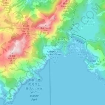
Name: Tai Long Wan Tsuen topographic map, elevation, terrain.
Location: Tai Long Wan Tsuen, Islands District, Hong Kong, PRC (22.20152 113.86410 22.24152 113.90410)
Average elevation: 121 m
Minimum elevation: -1 m
Maximum elevation: 462 m
Other topographic maps
Click on a map to view its topography, its elevation and its terrain.
Lantau South Country Park
Lantau South Country Park, Keung Shan Country Trail, Shek Pik, Tai Long Wan Tsuen, Islands District, Hong Kong, PRC
Average elevation: 109 m