
Ara Damansara Park topographic map
Interactive map
Click on the map to display elevation.
About this map
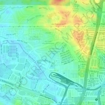
Name: Ara Damansara Park topographic map, elevation, terrain.
Average elevation: 31 m
Minimum elevation: 12 m
Maximum elevation: 67 m
Other topographic maps
Click on a map to view its topography, its elevation and its terrain.
Taman Bandaran Kelana Jaya
Malaysia > Selangor > PJ > PJS10
Taman Bandaran Kelana Jaya, SS 6, Kelana Jaya, PJS10, PJ, Selangor, Malaysia
Average elevation: 32 m