
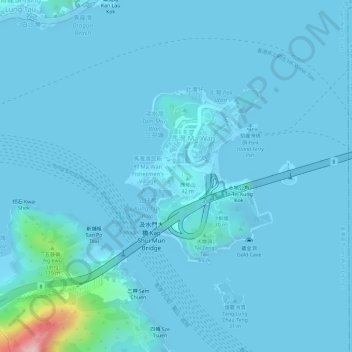
Ma Wan topographic map
Interactive map
Click on the map to display elevation.
About this map
Name: Ma Wan topographic map, elevation, terrain.
Average elevation: 12 m
Minimum elevation: -1 m
Maximum elevation: 216 m
Other topographic maps
Click on a map to view its topography, its elevation and its terrain.
Lin Fa Shan
Lin Fa Shan, 新界 New Territories, Tsuen Wan District, Hong Kong, DD106 2011, PRC
Average elevation: 342 m
Wo Yang Shan
Wo Yang Shan, 新界 New Territories, Tsuen Wan District, Hong Kong, PRC
Average elevation: 555 m
Tai Mo Shan Country Park
Tai Mo Shan Country Park, Lung Mun Country Trail, Wo Yi Hop, Sheung Kwai Chung, 新界 New Territories, Tsuen Wan District, Hong Kong, DD186 505, PRC
Average elevation: 370 m
Shek Lung Kung
Shek Lung Kung, 新界 New Territories, Tsuen Wan District, Hong Kong, DD106 2011, PRC
Average elevation: 255 m