
Saratoga County topographic map
Interactive map
Click on the map to display elevation.
About this map
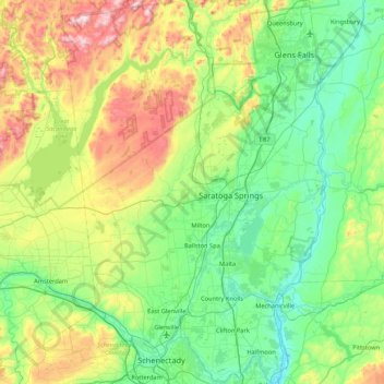
Name: Saratoga County topographic map, elevation, terrain.
Location: Saratoga County, New York, United States (42.77546 -74.16010 43.39797 -73.57327)
Average elevation: 218 m
Minimum elevation: 3 m
Maximum elevation: 833 m
Saratoga County is situated in the eastern portion of New York State, north of Albany, northwest of Troy, and east of Utica. According to the U.S. Census Bureau, the county has a total area of 844 square miles (2,190 km2), of which 810 square miles (2,100 km2) is land and 34 square miles (88 km2) (4.0%) is water. The Hudson River forms the eastern border of the county, while the Mohawk River demarcates its southern border. The highest elevation in Saratoga County is at the peak of Hadley Mountain in the Adirondack Mountains, at 2,675 feet (815 meters), while the lowest elevation is 69 feet (21 meters), at the waterfront of the Village of Waterford, at the confluence of the Mohawk and Hudson rivers.
Other topographic maps
Click on a map to view its topography, its elevation and its terrain.
City of Ithaca
United States > New York > Tompkins County
City of Ithaca, Tompkins County, New York, United States
Average elevation: 195 m
Walton Park
United States > New York > Orange County > Town of Monroe
Walton Park, Town of Monroe, Orange County, New York, United States
Average elevation: 213 m
Hudson River
Hudson River, New York, 12246, United States
Average elevation: 297 m
Town of Lake Pleasant
United States > New York > Hamilton County
Town of Lake Pleasant, Hamilton County, New York, United States
Average elevation: 640 m
South Troy
United States > New York > Rensselaer County > City of Troy
South Troy, City of Troy, Rensselaer County, New York, 12180, United States
Average elevation: 92 m
City of Glens Falls
United States > New York > Warren County > City of Glens Falls
City of Glens Falls, Warren County, New York, 12801, United States
Average elevation: 100 m
City of Geneva
United States > New York > Ontario County > City of Geneva
City of Geneva, Ontario County, New York, 14456, United States
Average elevation: 155 m
Essex County
United States > New York > Essex County
Essex County, New York, United States
Average elevation: 418 m
Manhattan
United States > New York > New York
Manhattan, New York, United States
Average elevation: 17 m
New York County
United States > New York > New York County > New York
New York County, New York, United States
Average elevation: 16 m