
Lantau South Country Park topographic map
Interactive map
Click on the map to display elevation.
About this map
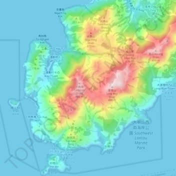
Name: Lantau South Country Park topographic map, elevation, terrain.
Average elevation: 109 m
Minimum elevation: -3 m
Maximum elevation: 462 m
Other topographic maps
Click on a map to view its topography, its elevation and its terrain.
Tai Long Wan Tsuen
Tai Long Wan Tsuen, Islands District, Hong Kong, PRC
Average elevation: 121 m