
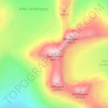
Sarektjåkkå topographic map
Interactive map
Click on the map to display elevation.
About this map
Name: Sarektjåkkå topographic map, elevation, terrain.
Average elevation: 1,671 m
Minimum elevation: 1,309 m
Maximum elevation: 2,070 m
Other topographic maps
Click on a map to view its topography, its elevation and its terrain.
Kebnekaise
Sweden > Norrbotten County > Kebnekaise Fjällstation
Kebnekaise, Kebnekaise Östra leden, Kebnekaise Fjällstation, Kiruna, Norrbotten County, Region Norrland, Sweden
Average elevation: 1,656 m
Kaskasatjåkka
Kaskasatjåkka, Kiruna, Norrbotten County, Region Norrland, Sweden
Average elevation: 1,557 m
Gällivare
Sweden > Norrbotten County > Gällivare
Gällivare, Norrbotten County, Region Norrland, 98231, Sweden
Average elevation: 403 m