
Herðubreið topographic map
Interactive map
Click on the map to display elevation.
About this map
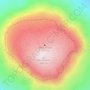
Name: Herðubreið topographic map, elevation, terrain.
Location: Herðubreið, Skútustaðahreppur, Northeastern Region, Iceland (65.17435 -16.34573 65.17445 -16.34563)
Average elevation: 1,182 m
Minimum elevation: 646 m
Maximum elevation: 1,641 m
Other topographic maps
Click on a map to view its topography, its elevation and its terrain.
Glacier Lagoon
Iceland > Sveitarfélagið Hornafjörður
Glacier Lagoon, Sveitarfélagið Hornafjörður, Eastern Region, Iceland
Average elevation: 100 m
Vestmannaeyjabær
Vestmannaeyjabær, Southern Region, Iceland
Average elevation: 10 m
Tindfjallajökull
Tindfjallajökull, Hungurfitaskáli, Rangárþing ytra, Southern Region, Iceland
Average elevation: 1,059 m
Kaldaklofsjökull
Kaldaklofsjökull, Laugavegur, Rangárþing ytra, Southern Region, Iceland
Average elevation: 1,035 m