
Grafton County topographic map
Interactive map
Click on the map to display elevation.
About this map
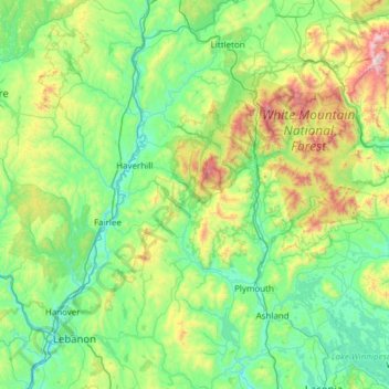
Name: Grafton County topographic map, elevation, terrain.
Location: Grafton County, New Hampshire, United States of America (43.52812 -72.33517 44.40665 -71.34686)
Average elevation: 424 m
Minimum elevation: 94 m
Maximum elevation: 1,902 m
Other topographic maps
Click on a map to view its topography, its elevation and its terrain.
Exeter
United States of America > New Hampshire > Exeter
Exeter, Rockingham County, New Hampshire, United States of America
Average elevation: 24 m
Merrimack County
United States of America > New Hampshire
Merrimack County, New Hampshire, United States of America
Average elevation: 251 m