
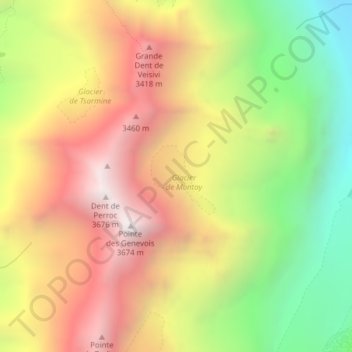
Glacier de Montay topographic map
Interactive map
Click on the map to display elevation.
About this map
Name: Glacier de Montay topographic map, elevation, terrain.
Average elevation: 2,835 m
Minimum elevation: 1,954 m
Maximum elevation: 3,666 m
Other topographic maps
Click on a map to view its topography, its elevation and its terrain.
Glacier du Mont Miné
Switzerland > Valais/Wallis > Evolène
Glacier du Mont Miné, Arolla - Cabane de la Tsa, Tsijiore Nouve, Evolène, Hérens, Valais/Wallis, 1983, Switzerland
Average elevation: 3,006 m
Dent Blanche
Switzerland > Valais/Wallis > Evolène
Dent Blanche, Evolène, Hérens, Valais/Wallis, 1983, Switzerland
Average elevation: 3,458 m