
White Island topographic map
Interactive map
Click on the map to display elevation.
About this map
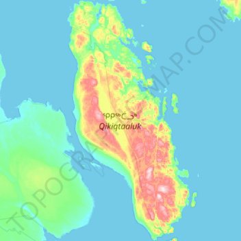
Name: White Island topographic map, elevation, terrain.
Location: White Island, Nunavut, Canada (65.54033 -85.15877 66.03072 -84.55142)
Average elevation: 39 m
Minimum elevation: -1 m
Maximum elevation: 361 m
Other topographic maps
Click on a map to view its topography, its elevation and its terrain.
Victoria and Albert Mountains
Victoria and Albert Mountains, Nunavut, Canada
Average elevation: 743 m
Sermilik Glacier
Sermilik Glacier, Sirmilik National Park, Nunavut, Canada
Average elevation: 1,188 m
Cornwallis Island
Cornwallis Island, Qikiqtani Region, Nunavut, X0A 0V0, Canada
Average elevation: 73 m
Prince of Wales Island
Prince of Wales Island, Nunavut, Canada
Average elevation: 31 m
Sirmilik National Park
Sirmilik National Park, Nunavut, Canada
Average elevation: 338 m