
Hérens topographic map
Interactive map
Click on the map to display elevation.
About this map
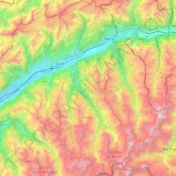
Name: Hérens topographic map, elevation, terrain.
Location: Hérens, Wallis, 2305, Switzerland (45.95490 7.34424 46.38617 7.61195)
Average elevation: 2,084 m
Minimum elevation: 462 m
Maximum elevation: 4,457 m
Other topographic maps
Click on a map to view its topography, its elevation and its terrain.
Hérémence
Switzerland > Wallis > Hérens
Hérémence, Hérens, Wallis, 1987, Switzerland
Average elevation: 2,329 m
Les Masses
Switzerland > Wallis > Hérens > Ayer > Les Masses
Les Masses, Ayer, Hérémence, Hérens, Wallis, 1987, Switzerland
Average elevation: 1,420 m
Nendaz
Switzerland > Wallis > Conthey
Nendaz, Conthey, Wallis, 1997, Switzerland
Average elevation: 1,771 m