
Wenshan District topographic map
Interactive map
Click on the map to display elevation.
About this map
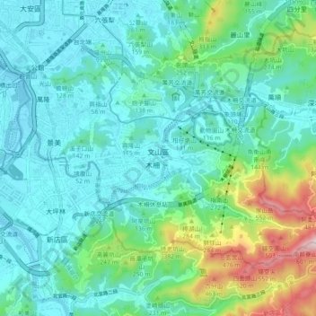
Name: Wenshan District topographic map, elevation, terrain.
Location: Wenshan District, Taipei, TW (24.96052 121.53074 25.01552 121.62000)
Average elevation: 123 m
Minimum elevation: -4 m
Maximum elevation: 592 m
Other topographic maps
Click on a map to view its topography, its elevation and its terrain.
Shiyuan Village
Shiyuan Village, Gouzikou, Wenshan District, Taipei, 11642, TW
Average elevation: 33 m
Guangfu Village
Guangfu Village, Chengnei, Zhongzheng District, Taipei, 10045, TW
Average elevation: 12 m