
Río Negro Province topographic map
Interactive map
Click on the map to display elevation.
About this map
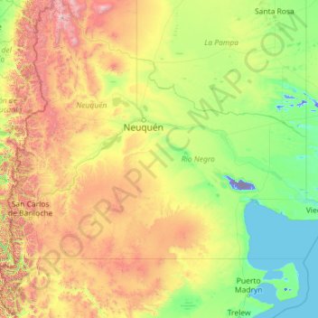
Name: Río Negro Province topographic map, elevation, terrain.
Location: Río Negro Province, Argentina (-42.00039 -71.91207 -37.57111 -62.78870)
Average elevation: 622 m
Minimum elevation: -71 m
Maximum elevation: 4,505 m
The climate of the province is temperate at low elevations, and very cold in the higher Andean peaks.