
Hamirpur topographic map
Interactive map
Click on the map to display elevation.
About this map
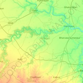
Name: Hamirpur topographic map, elevation, terrain.
Location: Hamirpur, Uttar Pradesh, India (25.40638 79.35259 26.16045 80.34407)
Average elevation: 137 m
Minimum elevation: 87 m
Maximum elevation: 293 m
Other topographic maps
Click on a map to view its topography, its elevation and its terrain.
Mountains
Mountains, Kānpur, Kanpur Dehat, Uttar Pradesh, India
Average elevation: 135 m
Jhansi
India > Uttar Pradesh > Jhansi
Jhansi, Jhānsi, Jhansi, Uttar Pradesh, 284001, India
Average elevation: 237 m