
Trio Island topographic map
Interactive map
Click on the map to display elevation.
About this map
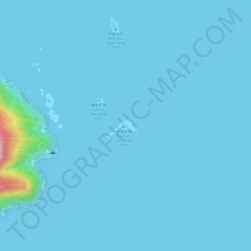
Name: Trio Island topographic map, elevation, terrain.
Location: Trio Island, Tai Wan Tau, Sai Kung District, Hong Kong, PRC (22.30049 114.31906 22.30168 114.32136)
Average elevation: 8 m
Minimum elevation: -1 m
Maximum elevation: 211 m
Other topographic maps
Click on a map to view its topography, its elevation and its terrain.
Kwun Tsai
Kwun Tsai, Tai Wan Tau, Sai Kung District, Hong Kong, PRC
Average elevation: 22 m
Tit Cham Chau
Tit Cham Chau, Tai Wan Tau, Sai Kung District, Hong Kong, CWIL 176, PRC
Average elevation: 17 m