
Centerville topographic map
Interactive map
Click on the map to display elevation.
About this map
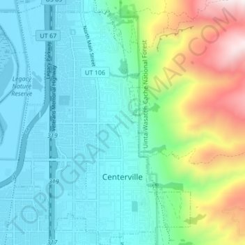
Name: Centerville topographic map, elevation, terrain.
Location: Centerville, Davis County, Utah, 84014, United States (40.90378 -111.91577 40.95473 -111.85341)
Average elevation: 1,521 m
Minimum elevation: 1,279 m
Maximum elevation: 2,291 m
Other topographic maps
Click on a map to view its topography, its elevation and its terrain.
Layton
United States > Utah > Davis County
Layton, Davis County, Utah, United States
Average elevation: 1,373 m
Bountiful
United States > Utah > Davis County
Bountiful, Davis County, Utah, 84010, United States
Average elevation: 1,477 m
Campbell
United States > Utah > Davis County > Bountiful
Campbell, Bountiful, Davis County, Utah, 84014, United States
Average elevation: 1,347 m
White
United States > Utah > Davis County > Sunset
White, Sunset, Davis County, Utah, 84015, United States
Average elevation: 1,382 m
West Point
United States > Utah > Davis County
West Point, Davis County, Utah, United States
Average elevation: 1,309 m
Mountains Meadows
United States > Utah > Davis County > North Salt Lake
Mountains Meadows, North Salt Lake, Davis County, Utah, 84054, United States
Average elevation: 1,411 m
Newmann
United States > Utah > Davis County > Farmington
Newmann, Farmington, Davis County, Utah, 84025, United States
Average elevation: 1,507 m
Clinton
United States > Utah > Davis County
Clinton, Davis County, Utah, United States
Average elevation: 1,341 m
Woods Cross
United States > Utah > Davis County
Woods Cross, Davis County, Utah, 84087, United States
Average elevation: 1,351 m
The Great Salt Lake Shorelands Preserve
United States > Utah > Davis County
The Great Salt Lake Shorelands Preserve, Davis County, Utah, United States
Average elevation: 1,292 m
North Salt Lake
United States > Utah > Davis County
North Salt Lake, Davis County, Utah, 84054, United States
Average elevation: 1,429 m
Syracuse
United States > Utah > Davis County
Syracuse, Davis County, Utah, 84075, United States
Average elevation: 1,305 m
West Bountiful
United States > Utah > Davis County
West Bountiful, Davis County, Utah, United States
Average elevation: 1,300 m
North Salt Lake
United States > Utah > Davis County > North Salt Lake > North Salt Lake
North Salt Lake, Davis County, Utah, 84054, United States
Average elevation: 1,422 m
Clearfield
United States > Utah > Davis County
Clearfield, Davis County, Utah, 84015, United States
Average elevation: 1,358 m
Farmington
United States > Utah > Davis County > Farmington > Farmington
Farmington, Davis County, Utah, 84025, United States
Average elevation: 1,595 m
Kaysville
United States > Utah > Davis County
Kaysville, Davis County, Utah, 84037, United States
Average elevation: 1,353 m
Farmington
United States > Utah > Davis County
Farmington, Davis County, Utah, 84025, United States
Average elevation: 1,553 m