
West Kalimantan topographic map
Interactive map
Click on the map to display elevation.
About this map
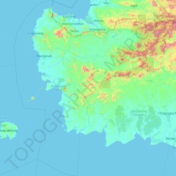
Name: West Kalimantan topographic map, elevation, terrain.
Location: West Kalimantan, Indonesia (-4.71531 108.13865 2.31464 114.20543)
Average elevation: 52 m
Minimum elevation: -4 m
Maximum elevation: 2,127 m
Other topographic maps
Click on a map to view its topography, its elevation and its terrain.
Sanggau
Indonesia > West Kalimantan > Sanggau
Sanggau, West Kalimantan, Indonesia
Average elevation: 42 m
Kapuas River
Kapuas River, West Kalimantan, 78611, Indonesia
Average elevation: 141 m
Pontianak
Indonesia > West Kalimantan > Pontianak
Pontianak, West Kalimantan, 78243, Indonesia
Average elevation: 5 m