Geolocate

Nîmes topographic map

Interactive map

Click on the map to display elevation.

About this map

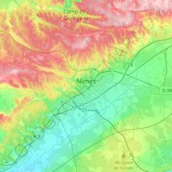
Name: Nîmes topographic map, elevation, terrain.

Location: Nîmes, Gard, Occitania, Metropolitan France, France (43.74127 4.23567 43.92302 4.44966)

Average elevation: 90 m

Minimum elevation: 14 m

Maximum elevation: 214 m

Other topographic maps

Click on a map to view its topography, its elevation and its terrain.

Mont Aigoual

France > Occitania > Gard > Val-d'Aigoual

Average elevation: 1,355 m

Bay

France > Occitania > Gard > Canaules-et-Argentières

Average elevation: 98 m

Camp Bernard

France > Occitania > Gard > Val-d'Aigoual > Fenouillet

Average elevation: 636 m

Le Fageas

France > Occitania > Gard > L'Estréchure

Average elevation: 854 m

Espinassous

France > Occitania > Gard > Lanuéjols > Espinassous

Average elevation: 866 m