
Sapporo topographic map
Interactive map
Click on the map to display elevation.
About this map
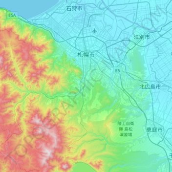
Name: Sapporo topographic map, elevation, terrain.
Location: Sapporo, Ishikari Subprefecture, Hokkaido Prefecture, Japan (42.78071 140.99050 43.18999 141.50542)
Average elevation: 273 m
Minimum elevation: -2 m
Maximum elevation: 1,299 m
Sapporo is a city located in the southwest part of Ishikari Plain and the alluvial fan of the Toyohira River, a tributary stream of the Ishikari River. It is part of Ishikari Subprefecture. Roadways in the urban district are laid to make a grid plan. The western and southern parts of Sapporo are occupied by a number of mountains including Mount Teine, Maruyama, and Mount Moiwa, as well as many rivers including the Ishikari River, Toyohira River, and Sōsei River. Sapporo has an elevation of 29 m (95 ft 2 in)