
Santa Cruz de Tenerife topographic map
Interactive map
Click on the map to display elevation.
About this map
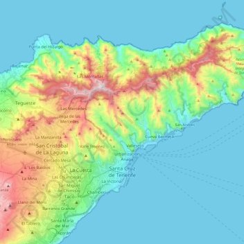
Name: Santa Cruz de Tenerife topographic map, elevation, terrain.
Location: Santa Cruz de Tenerife, Canary Islands, Spain (28.40973 -16.34583 28.60540 -16.11938)
Average elevation: 242 m
Minimum elevation: -1 m
Maximum elevation: 1,012 m
Other topographic maps
Click on a map to view its topography, its elevation and its terrain.
Macizo de Anaga
Spain > Canary Islands > Santa Cruz de Tenerife
Macizo de Anaga, Santa Cruz de Tenerife, Canary Islands, Spain
Average elevation: 201 m