
Rankin County topographic map
Interactive map
Click on the map to display elevation.
About this map
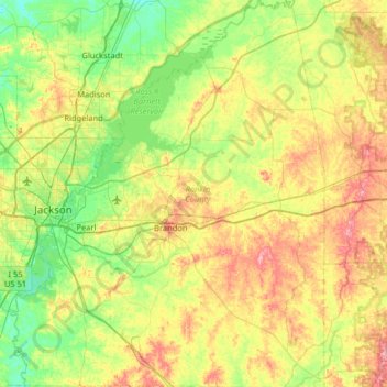
Name: Rankin County topographic map, elevation, terrain.
Location: Rankin County, Mississippi, USA (32.04709 -90.25062 32.59338 -89.73014)
Average elevation: 108 m
Minimum elevation: 62 m
Maximum elevation: 186 m
Other topographic maps
Click on a map to view its topography, its elevation and its terrain.
Starkville
USA > Mississippi > Starkville
Starkville, Oktibbeha County, Mississippi, USA
Average elevation: 93 m