
Eaton County topographic map
Click on the map to display elevation.
About this map
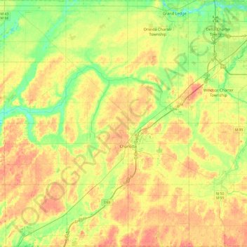
Name: Eaton County topographic map, elevation, terrain.
Location: Eaton County, Michigan, United States (42.42145 -85.07558 42.77073 -84.60042)
Average elevation: 273 m
Minimum elevation: 243 m
Maximum elevation: 306 m
Other topographic maps
Click on a map to view its topography, its elevation and its terrain.
Grand Mere State Park
United States > Michigan > Berrien County > Lincoln Charter Township
Average elevation: 185 m
Old Mission
United States > Michigan > Grand Traverse County
Old Mission is located just east of M-37 near the tip of Old Mission Peninsula about 16 miles (25.75 km) north of Traverse City. The community was built along Old Mission Harbor, which is a small safe haven along the East Arm of Grand Traverse Bay. The community sits at an elevation of 587 feet (179 m) above…
Average elevation: 190 m
Hillcrest Orchard
United States > Michigan > Monroe County > LaSalle Township
Average elevation: 186 m
Genessee County Recreational Area
United States > Michigan > Genesee County > Genesee Charter Township
Average elevation: 231 m
Whitefish Point
United States > Michigan > Chippewa County > Whitefish Township
Average elevation: 179 m
Mount Arvon
United States > Michigan > Baraga County > L'Anse Township
Mount Arvon (/ɑːrvɒn/ ARR-vahn) at 1,979 feet (603 m), is the highest natural point in the U.S. state of Michigan. Located in L'Anse Township, Baraga County, Mount Arvon is part of the Huron Mountains. It rises about eight miles (13 km) south of Lake Superior (elevation 591 feet [180 m]). On the list of…
Average elevation: 526 m
Charlevoix South Pier Light
United States > Michigan > Charlevoix County > Charlevoix
Average elevation: 180 m
Lower Peninsula Experimental Forest
United States > Michigan > Wexford County > South Branch Township
Average elevation: 314 m
Echo Lake
United States > Michigan > Kent County > Grand Rapids Charter Township
Average elevation: 240 m
Christie Lake
United States > Michigan > Van Buren County > Lawrence Township
Average elevation: 238 m
Mcnearney Lake
United States > Michigan > Chippewa County > Bay Mills Township
Average elevation: 286 m
Edgewater Beach
United States > Michigan > Cheboygan County > Mackinaw Township
Average elevation: 187 m
Cambridge Junction
United States > Michigan > Lenawee County > Cambridge Township
Average elevation: 305 m
Green Oak
United States > Michigan > Livingston County > Green Oak Charter Township
Average elevation: 275 m
Centennial Heights
United States > Michigan > Houghton County > Calumet Township
Average elevation: 364 m
Boyne Mountain
United States > Michigan > Charlevoix County > Boyne Valley Township
Average elevation: 263 m
Van Riper State Park
United States > Michigan > Marquette County > Michigamme Township
Average elevation: 489 m