
Narmada topographic map
Interactive map
Click on the map to display elevation.
About this map
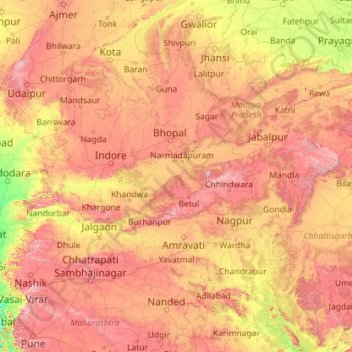
Name: Narmada topographic map, elevation, terrain.
Average elevation: 380 m
Minimum elevation: 0 m
Maximum elevation: 1,440 m
Other topographic maps
Click on a map to view its topography, its elevation and its terrain.
Makka
India > Madhya Pradesh > Makka
Makka, Nainpur Tahsil, Mandla, Madhya Pradesh, India
Average elevation: 467 m
Sagar
India > Madhya Pradesh > Sagar
Sagar, Sagar Tahsil, Sagar, Madhya Pradesh, 470001, India
Average elevation: 515 m