
Glacier du Mont Miné topographic map
Interactive map
Click on the map to display elevation.
About this map
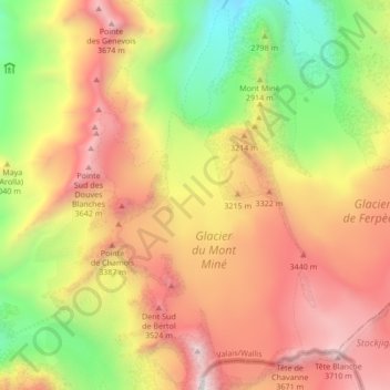
Name: Glacier du Mont Miné topographic map, elevation, terrain.
Average elevation: 3,006 m
Minimum elevation: 2,125 m
Maximum elevation: 3,826 m
Other topographic maps
Click on a map to view its topography, its elevation and its terrain.
Glacier de Montay
Switzerland > Valais/Wallis > Evolène
Glacier de Montay, Barrage de Ferpècle, Renoillin, Evolène, Hérens, Valais/Wallis, 1983, Switzerland
Average elevation: 2,835 m
Dent Blanche
Switzerland > Valais/Wallis > Evolène
Dent Blanche, Evolène, Hérens, Valais/Wallis, 1983, Switzerland
Average elevation: 3,458 m