
Gongshan Derung and Nu Autonomous County topographic map
Interactive map
Click on the map to display elevation.
About this map
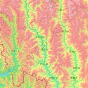
Name: Gongshan Derung and Nu Autonomous County topographic map, elevation, terrain.
Average elevation: 3,256 m
Minimum elevation: 1,312 m
Maximum elevation: 5,871 m
Other topographic maps
Click on a map to view its topography, its elevation and its terrain.
Shangri-La County
Shangri-La County, Dêqên Tibetan Autonomous Prefecture, Yunnan, PRC
Average elevation: 3,342 m
Yulong Nakhi Autonomous County
PRC > Yunnan > Lijiang City
Yulong Nakhi Autonomous County, Lijiang City, Yunnan, PRC
Average elevation: 2,929 m
Lugu Lake
PRC > Yunnan > Lijiang City > Luoshui
Lugu Lake, S307, Luoshui, Ninglang Yi Autonomous County, Lijiang City, Yunnan, PRC
Average elevation: 2,750 m