
Hofstade topographic map
Interactive map
Click on the map to display elevation.
About this map
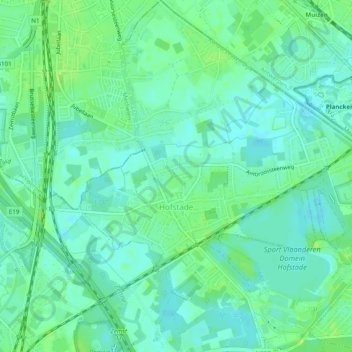
Name: Hofstade topographic map, elevation, terrain.
Location: Hofstade, Zemst, Halle-Vilvoorde, Vlaams-Brabant, 1981, België (50.97847 4.48037 51.00931 4.52870)
Average elevation: 8 m
Minimum elevation: 2 m
Maximum elevation: 14 m
Other topographic maps
Click on a map to view its topography, its elevation and its terrain.
Zemst-Bos
België > Vlaams-Brabant > Halle-Vilvoorde > Zemst
Ter hoogte van de Kesterbeek ligt het dorp op zo'n 12 meter hoogte, de rest ligt op 13 meter hoogte. Het laagste punt in de omgeving wordt gevormd door de vijver van het Dalemansbos, ten noordoosten van het dorp (11 meter hoogte). De hoogste punten van Zemst-Bos liggen bij Haverenblok en het Zwartland (15…
Average elevation: 11 m